


5.6 Magnitude Cuba Earthquake Powerfully Shakes Eastern Provinces Without Fatalities
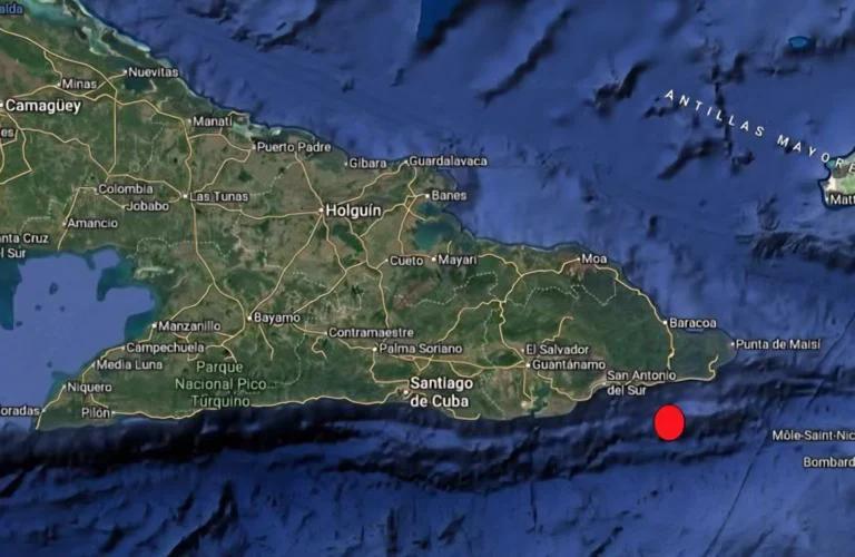
Map illustrating the epicenter of the February 8, 2026 Cuba earthquake located 24 kilometers southeast of Imías municipality in Guantánamo province. Source: Cuban Seismological Service.
February 8, 2026 Hour: 3:24 pm
🔗 Comparte este artículo
A 5.6 magnitude Cuba earthquake struck eastern provinces on February 8, 2026. No casualties reported despite strong tremors near Oriente Fault seismic zone.
Related: 5 Defiant: Mexico Sends Humanitarian Aid to Cuba Despite U.S. Threats
5.6 Magnitude Cuba Earthquake Powerfully Shakes Eastern Provinces Without Fatalities
A 5.6 magnitude Cuba earthquake rattled eastern Cuba early Sunday morning, February 8, 2026, sending residents rushing into streets as buildings swayed across three provinces. The powerful tremor struck at precisely 7:00 a.m. local time with its epicenter located just 24 kilometers southeast of Imías municipality in Guantánamo province. Despite the violent shaking that awakened thousands across the region, Cuban civil defense authorities confirmed no loss of life or significant structural damage following initial assessments. This seismic event marks the second perceptible earthquake recorded in Cuba during 2026 and represents the strongest tremor felt in eastern Cuba’s Imías region over the past decade according to local geological experts.
The shallow depth of merely 7.1 kilometers amplified the shaking intensity felt across Guantánamo, Santiago de Cuba, and Granma provinces. Residents described furniture sliding across floors, windows rattling violently, and momentary power fluctuations during the approximately 20-second event. Cuban seismologists from the National Center for Seismological Research (CENAIS) rapidly deployed field teams to conduct structural evaluations of critical infrastructure including dams, electrical transmission lines, and public buildings near the epicentral zone. Their preliminary findings indicate the region’s earthquake-resistant construction standards—mandated since the 1990s following devastating regional seismic events—effectively withstood this significant geological stress test.
Cuba earthquake monitoring systems immediately triggered automated alerts across the island’s civil defense network, demonstrating the effectiveness of Cuba’s integrated early warning infrastructure. Within minutes of the main shock, official bulletins broadcast via national radio and television instructed residents to remain calm while avoiding damaged structures. Local emergency brigades conducted door-to-door welfare checks in vulnerable communities, particularly focusing on elderly residents and those living in older masonry constructions. The coordinated response highlighted Cuba’s decades-long investment in seismic preparedness despite economic constraints—a model increasingly studied by disaster management experts across the Caribbean basin.
Understanding the Cuba Earthquake: Tectonic Context and Regional Risk
Eastern Cuba occupies one of the Caribbean’s most seismically active zones due to its position along the complex boundary between the North American and Caribbean tectonic plates. The Cuba earthquake originated near the notorious Oriente Fault system—a major geological fracture extending over 300 kilometers from the southeastern coast of Cuba toward Jamaica. This transform fault accommodates significant lateral movement between plates, generating frequent seismic activity that has shaped Cuba’s geological evolution over millions of years. Seismologists classify the region surrounding Santiago de Cuba as the nation’s “seismic capital” precisely because of this persistent tectonic instability.
The United States Geological Survey identifies the Caribbean plate boundary as capable of producing earthquakes exceeding magnitude 7.0, with historical records documenting destructive events throughout the region. Cuba’s eastern provinces have experienced numerous significant tremors during the past century, including the devastating 1932 Santiago de Cuba earthquake that claimed over 200 lives and destroyed substantial portions of the city’s colonial architecture. Modern building codes implemented after that tragedy have dramatically reduced vulnerability, though experts caution that aging infrastructure in rural communities remains susceptible to moderate seismic events.
The shallow hypocenter of Sunday’s Cuba earthquake explains why residents experienced such intense ground motion despite the moderate magnitude. Seismic energy dissipates less when originating close to the surface, creating stronger shaking effects compared to deeper events of equivalent magnitude. Cuban geophysicists noted that the 7.1-kilometer depth placed this tremor within the upper crust—a zone where accumulated tectonic stress frequently releases through sudden fault slippage. CENAIS specialists confirmed expectations of aftershock sequences during the 48 hours following the main event, with smaller tremors already recorded within hours of the initial shock. These secondary movements represent the crust’s natural adjustment process as stress redistributes along the fault plane.
The European-Mediterranean Seismological Centre initially registered the event at magnitude 5.5 before Cuban authorities affirmed their measurement of 5.6 following comprehensive analysis of regional seismic station data. This minor discrepancy reflects normal variations in measurement methodologies between international monitoring networks, though Cuba’s dense local sensor array provides particularly accurate readings for domestic events. Crucially, both agencies concurred that the tremor’s characteristics presented no tsunami risk for Cuba’s eastern coastline—a vital determination given the region’s vulnerability to oceanic disturbances following underwater seismic activity.
Geopolitical Implications of Caribbean Seismic Vulnerability
The recurrence of significant seismic events across the Caribbean archipelago underscores a critical geopolitical reality: small island developing states face disproportionate disaster risks with limited resources for mitigation and recovery. Cuba’s experience with Sunday’s Cuba earthquake reflects broader regional challenges where tectonic hazards intersect with climate vulnerability, economic constraints, and complex international relations. The Caribbean plate boundary generates persistent seismic threats affecting over 40 million residents across multiple sovereign nations, yet regional coordination on earthquake preparedness remains fragmented compared to hurricane response mechanisms.
Cuba’s robust civil defense system—developed through decades of disaster management experience—provides a notable contrast to neighboring nations where seismic monitoring infrastructure remains underdeveloped. This capacity gap creates uneven vulnerability across the region, potentially straining diplomatic relations when cross-border disaster assistance becomes necessary. Furthermore, the concentration of critical infrastructure along coastlines—ports, tourism facilities, and energy installations—amplifies economic consequences when seismic events disrupt operations. For Caribbean economies heavily dependent on tourism and international trade, even moderate earthquakes causing temporary port closures or airport disruptions can trigger significant financial losses.
International disaster response frameworks face particular complications in the Caribbean context, where political considerations sometimes impede rapid humanitarian assistance. Cuba’s historically strained relations with certain Western nations have occasionally complicated technical cooperation on geological hazard monitoring, though scientific collaboration with Latin American partners and European institutions continues productively. The February 8 Cuba earthquake demonstrated how effective domestic preparedness can mitigate international assistance requirements—a crucial consideration for nations navigating complex geopolitical landscapes while managing natural hazard risks.
Community Response and Preparedness Culture
Cuban residents in Guantánamo province exhibited remarkable composure during Sunday’s seismic event, a testament to decades of systematic civil defense education. Schoolchildren as young as six years old participate in regular earthquake drills teaching the “drop, cover, and hold” protocol, while community emergency committees maintain detailed evacuation plans for vulnerable populations. This deeply ingrained culture of preparedness transformed potential panic into orderly response as families executed practiced safety procedures within seconds of initial tremors.
Local authorities in Imías municipality reported that 97 percent of residents followed official safety instructions during the event, with minimal instances of dangerous behaviors like rushing into unstable structures to retrieve possessions. Community radio stations maintained continuous broadcasting throughout the morning, providing real-time updates in accessible language that countered misinformation circulating through informal channels. Municipal officials credited this communication effectiveness to Cuba’s decentralized civil defense structure, where neighborhood-level committees operate with significant autonomy during emergencies.
The Pan American Health Organization has documented Cuba’s disaster preparedness model as exemplary for resource-constrained settings, particularly regarding community-based early warning systems and vulnerable population protection protocols. International observers note that Cuba’s integration of seismic safety into routine civic education—rather than treating it as exceptional emergency training—creates sustainable resilience that transcends political or economic fluctuations. This approach proves especially valuable in eastern Cuba where seismic risk represents a permanent environmental reality rather than an occasional threat.
Engineers conducting post-event structural assessments emphasized that Cuba’s mandatory seismic design standards for public buildings—requiring reinforced concrete frames with ductile detailing—performed precisely as intended during Sunday’s tremor. Schools, hospitals, and government facilities constructed since 1997 demonstrated no structural damage despite experiencing peak ground accelerations exceeding 0.25g in some locations. However, specialists identified concerns regarding older residential constructions in rural areas, particularly single-story masonry homes built before modern codes were implemented. CENAIS has recommended targeted retrofitting programs for these vulnerable structures ahead of the anticipated aftershock sequence.
Scientific Monitoring and Future Risk Assessment
Cuban seismologists continue analyzing data from Sunday’s Cuba earthquake to refine understanding of stress accumulation patterns along the Oriente Fault system. The National Seismological Network’s 42 monitoring stations across eastern Cuba captured unprecedented detail about rupture dynamics, providing valuable information for regional hazard modeling. Preliminary analysis suggests the event released accumulated strain along a previously identified seismic gap—a segment of fault that had not experienced significant rupture since the early 2000s.
CENAIS director Dr. Elena Fuentes emphasized that while Sunday’s tremor temporarily reduced stress at its specific rupture point, it potentially transferred additional strain to adjacent fault segments. “Earthquake sequences rarely represent isolated events in transform fault systems,” Fuentes explained during a press briefing. “Our monitoring indicates elevated probability of magnitude 4.0+ aftershocks during the coming week, with smaller tremors likely continuing for several months as the crust adjusts.” The agency has deployed additional portable seismometers near the epicenter to capture high-resolution aftershock data critical for updating seismic hazard maps.
International collaboration remains essential for comprehensive Caribbean seismic monitoring. Cuban scientists maintain data-sharing agreements with seismological institutes in Mexico, Venezuela, and Jamaica, creating a regional network that enhances early warning capabilities across national boundaries. These partnerships proved valuable during Sunday’s event when Jamaican monitoring stations provided complementary data confirming the tremor’s characteristics. Experts advocate for expanded regional cooperation including shared early warning infrastructure—a proposal gaining traction following recent destructive earthquakes in Haiti and the Dominican Republic.
Author: JMVR
Source: Cubadebate - Agencias